Whitehall
A small railway settlement once described with a church, hotel, store and sawmill — and one of the least documented places along the old corridor.
Whitehall is easy to pass on Highway 518 without realizing that it once appeared in national gazetteers as a small railway village with a church, store, hotel and sawmill. The railway gave the settlement a place on the map, and the original SeguinTrail.ca maps preserved Whitehall as one of the eastern access points along the former grade.
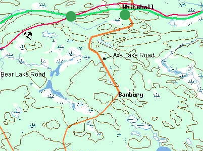
A tiny village captured in a gazetteer
Lovell's early-twentieth-century Gazetteer of the Dominion of Canada describes Whitehall as a post village in Parry Sound District on the Ottawa division of the Grand Trunk Railway, about 14 miles from Emsdale on the Toronto–North Bay line. The entry is short but unusually valuable: it lists a Methodist church, one store, one hotel and one sawmill, with a population of about 40.
Those few lines show that Whitehall was more than a whistle-stop name. A settlement of forty people could support several basic institutions because the railway connected it to a much larger network. The hotel suggests travellers or railway traffic; the sawmill reflects the timber economy; the store and church indicate a settled community rather than a temporary camp.
Whitehall on the railway
Federal postal records from the same era refer to “Whitehall and Railway Station” on the Grand Trunk. The station lay on the former Booth route between Bear Lake/Seguin Falls to the west and Sprucedale/Scotia to the east. After the Grand Trunk was absorbed into Canadian National, the line's importance declined with the rest of the western OA&PS corridor.
Because Whitehall left relatively little published material behind, small sources — gazetteers, postal records, old maps, family photographs and the surviving landscape — are especially important.
Whitehall today
Whitehall remains an officially recognized settlement area in the Township of McMurrich/Monteith. The Township's planning documents specifically group Whitehall with Sprucedale and Bear Lake as settlement areas recognized for their historic roles in local development.
A corrected archive clue
The old file whfarm.jpg was once assumed to relate to Whitehall. The site author has since identified it as the family-known “White Horse Farm” on Highway 518 near Diamond Lake. It has been moved to its own local-memory page rather than being left here under an incorrect caption.
Do you have a photograph of Whitehall railway village?
We have useful maps and documentary material for this location, but additional historic or present-day photographs would make this page and its map hotspot much stronger. Contributions are moderated before publication.
Sources & further research
The story above is kept on this site; these links are provided for provenance and for readers who want to go deeper.
- Original SeguinTrail.ca archive:
whfarm.jpg, trail maps and Whitehall hotspot. - Lovell's Gazetteer of the Dominion of Canada — Whitehall entry records church, store, hotel, sawmill and population.
- Township of McMurrich/Monteith Official Plan material — recognizes Whitehall as a historic settlement area.
- Canada Postmaster General report (1911) — lists Whitehall and railway station.