Station
A named railway stopping point that could range from a substantial building to a modest rural facility, depending on era and traffic.
Why summits, rivers, lakes, sidings and junctions shaped the western OA&PS corridor.
The western end of the OA&PS was not a flat rail trail laid conveniently through level country. Railway engineers had to thread the line through Canadian Shield terrain, rivers, lakes, marshes, summits and existing railway crossings. A 1964 historical profile of the Grand Trunk's Ottawa Division preserves a remarkable sequence of elevations and operating points that helps explain why the line looks the way it does on the ground.
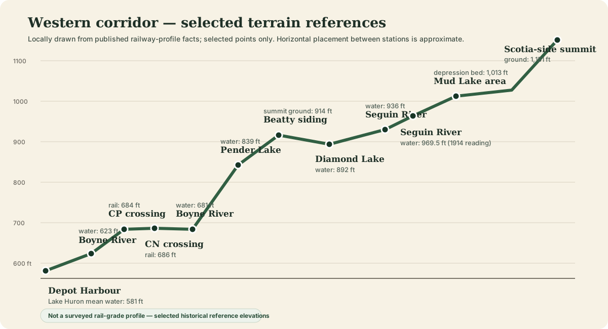
From Georgian Bay at Depot Harbour the railway climbed steadily into the interior. The historical profile records Lake Huron mean water at roughly 581 feet above sea level and a summit near the Scotia side of this western section at 1,151 feet. That difference — more than 500 feet — helps explain the fills, cuts, bridge sites and long gentle grades visible along the old right-of-way.
The full OA&PS crossed still higher country farther east. The same published profile describes the railway as generally undulating, gives a maximum grade of about one percent, and identifies the highest point on the line at approximately 1,605 feet. From there the railway eventually dropped more than a thousand feet toward Depot Harbour.
The summit designation is also a practical location clue: together with station mileage and lot/concession mapping, it can help identify where the siding sat on the ground.
The western profile repeatedly records water elevations: the Boyne River, Pender Lake, Diamond Lake, the Seguin River and Georgian Bay. Railway engineers needed a grade that remained gentle while crossing a landscape that rises and falls sharply around those waters. The result was the familiar railway geometry we see today — long curves, rock cuts, fills, culverts and major bridge sites rather than a road that simply follows property lines.
A named railway stopping point that could range from a substantial building to a modest rural facility, depending on era and traffic.
A parallel or auxiliary track used for meeting trains, setting out cars, loading traffic or other operating purposes. A siding name does not necessarily imply a community.
A point where railway routes connected or crossed. James Bay Junction and Scotia Junction were particularly important because they tied the OA&PS to other systems.
A small passenger point that might have had little more than a platform or shelter. Historic names can therefore survive even when no building foundation is obvious today.
The underlying profile appeared in the June 1964 issue of Canadian Rail in an article by Omer Lavallée. Because that publication remains a research source rather than a public-domain map we can freely republish, SeguinTrail.ca uses the factual data to create its own local diagrams and explanations instead of copying the page image.
Grades and summits only matter because trains had to work across them. Government and timetable records now let the site connect the physical railway to the traffic it carried: millions of bushels of grain through Depot Harbour, a sizeable locomotive and freight-car fleet, and daily passenger trains that took most of a day between Ottawa and the western terminal.
Open Traffic, Trains & Timetables → for locally reconstructed grain statistics, equipment counts and the 1908 end-to-end passenger schedule.