Beatty’s
A vanished station narrowed down through gazetteers, railway profiles and an unexpected geological record.
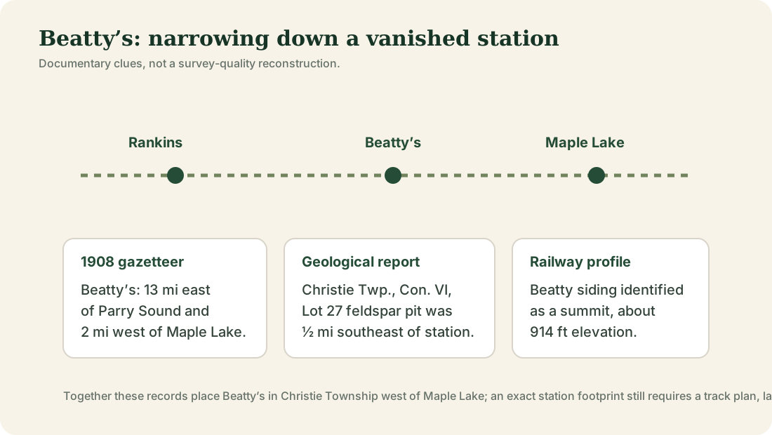
Beatty’s was a small station on the former OA&PS / Grand Trunk route west of Maple Lake, but its exact footprint has almost disappeared from public memory. Several independent records now narrow its location and show that the name belonged to a real railway point in Christie Township.
What the 1908 gazetteer tells us
Lovell’s Gazetteer of the Dominion of Canada describes Beatty’s as a station in Parry Sound District on the Parry Sound & Ottawa division of the Grand Trunk Railway. It places the station about 13 miles east of Parry Sound and two miles west of Maple Lake. That agrees with station lists that put Beatty’s between Rankins and Maple Lake Station, later known as Swords.
A geological report gives a much stronger location clue
An Ontario geological report describing a feldspar occurrence in Christie Township, Concession VI, Lot 27 records a small pit worked in 1923–24 by the Industrial Minerals Corporation of Canada. The report says the mine lay one-half mile southeast of what was formerly Beatty station on the abandoned Canadian National line through Christie Township.
That sentence is unusually useful because it ties the vanished station to the township survey rather than merely to railway mileage. The feldspar pit itself is described as being on the north shore of a small lake on Lot 27, Concession VI. A future comparison with historical lot maps and railway plans may therefore be able to place Beatty’s much more precisely.
A summit on the railway
The historical railway elevation profile used elsewhere on this site identifies Beatty siding as a summit at roughly 914 feet. That makes geographic sense in the rolling high ground between Rankins and Maple Lake and provides another clue for matching the old railway grade to the historic station site.
See the western terrain interpretation →
The Beatty name in the district
The surname itself has deep roots around Parry Sound. The prominent William Beatty family was involved in the early development of Parry Sound and in the Parry Sound Colonization Railway, the unfinished western railway later taken over by J.R. Booth. The 1879 Foley Township atlas transcription also contains a Beatty landholder. In local memory, the site author recalls Beatty as a familiar surname in the Orrville area.
Why the local surname matters
The Beatty surname is not an abstract name imported from somewhere else. The family was prominent in the development of Parry Sound itself, a Beatty landholder appears on the late-1870s Foley Township map transcription, and the site author remembers Beatty as a familiar surname around Orrville. Together those facts make a local naming connection plausible enough to investigate seriously.
They still do not tell us which Beatty, if any, supplied the station name. The strongest way to settle that question would be to match the station footprint in Christie Township to nineteenth-century land records, census households, directories or a railway/post-office document that names a nearby property owner.
1907 newspaper files
A railway-history research index lists two 1907 Beatty’s files, including one associated with Depot Harbour. The titles indicate that Beatty’s appeared in contemporary railway reporting, but the underlying clippings still need to be read before any accident details, train numbers or casualties can be stated reliably.
Do you have a photograph of Beatty’s station area?
We have useful maps and documentary material for this location, but additional historic or present-day photographs would make this page and its map hotspot much stronger. Contributions are moderated before publication.
Sources & evidence
- Lovell’s Gazetteer of the Dominion of Canada (1908), Beatty’s station entry.
- D. F. Hewitt, Ontario Department of Mines, Geology and Mineral Deposits of the Parry Sound–Huntsville Area (1967): Christie Township Concession VI, Lot 27, locating the feldspar pit one-half mile southeast of the former Beatty station.
- Historical OA&PS / Grand Trunk elevation profile identifying Beatty siding as a summit at about 914 ft.
- 1879 township atlas study for the pre-railway Beatty surname clue in Foley.