The 1899 fire-insurance plan
A building-by-building snapshot of the railway town and harbour only a few years after its creation.
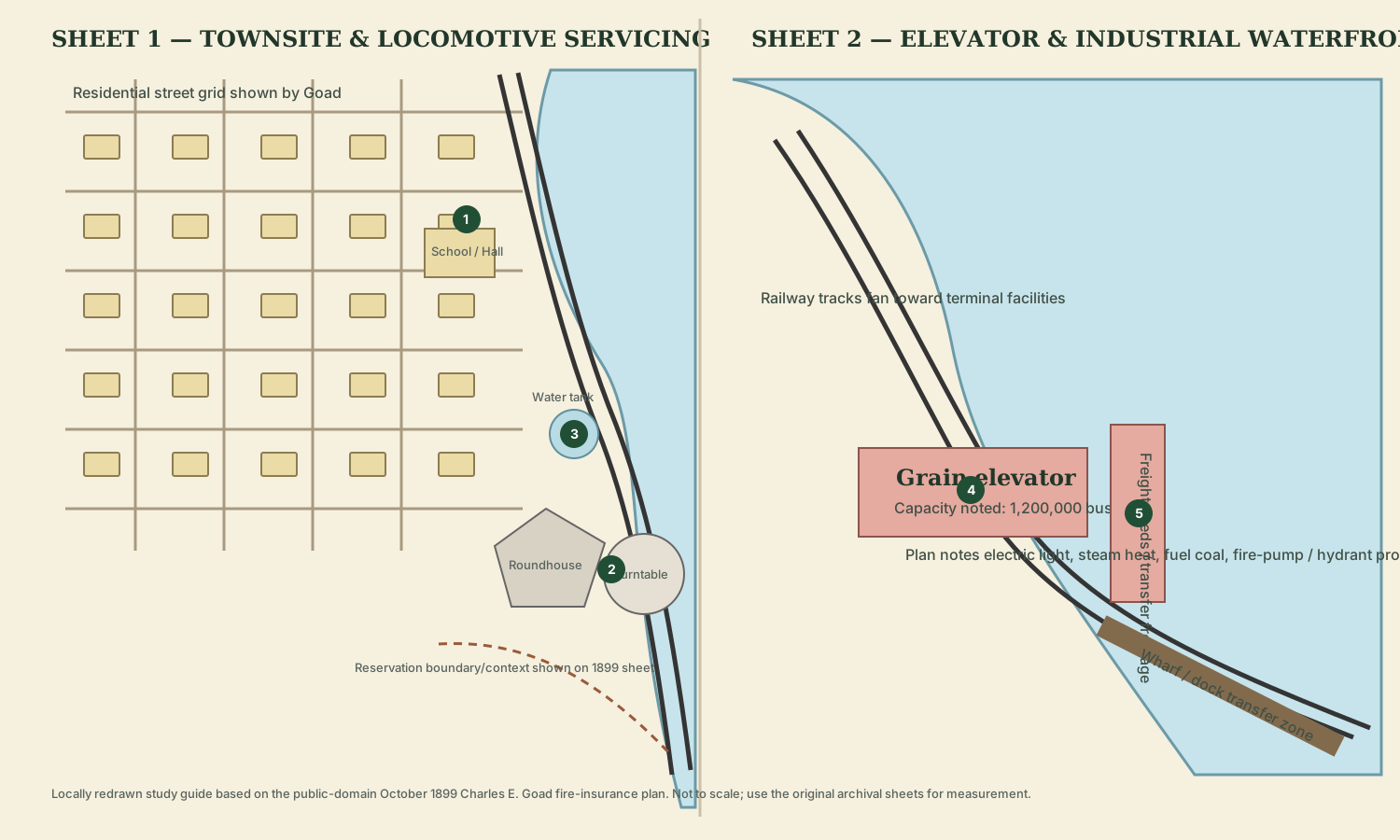
Charles E. Goad's fire-insurance plan is one of the most useful surviving documents for understanding how Depot Harbour was laid out. It records a residential street grid, a school/hall, railway servicing facilities, a roundhouse and turntable, a water tank, the grain elevator, freight sheds and the industrial waterfront.
New: sheet-by-sheet walkthrough
The 1899 plan has now been transcribed into a more detailed two-sheet study with street names, railway plant, elevator and freight-shed notes.
How to use the plan
Click one of the numbered green points on the diagram to identify major features in the 1899 town and terminal layout.
Rows of company housing and community buildings occupied the higher ground west of the harbour.
The roundhouse, turntable and water facilities show that Depot Harbour was a working terminal, not merely a loading dock.
The elevator, sheds, railway tracks and wharves were arranged for rapid transfer between ships and trains.
What the plan tells us
The sheet title gives the population as roughly 300 in October 1899, showing how quickly the settlement had begun to grow. The residential portion is drawn as a planned grid rather than an older organic village. The school/hall appears among the housing, while the railway plant sits closer to the industrial edge.
On the waterfront sheet, the elevator is annotated with a capacity of 1,200,000 bushels. The plan also notes electric lighting, steam heat, fuel coal and fire-pump infrastructure. Those annotations are a reminder that Depot Harbour was conceived as a modern industrial transfer port rather than a temporary lumber camp.
Another historically important feature is the boundary language on the plan. The town and railway development were placed on Parry Island beside and through lands then identified on the insurance map as an “Indian Reservation.” Today the former Depot Harbour townsite is on Wasauksing First Nation. That context belongs in the history of the port, not in a footnote.
Reading the plan as a town, not just a railway terminal
The strongest feature of the Goad sheets is that they put ordinary town life and heavy railway industry on the same document. Rows of houses and a school/hall sit only a short distance from locomotive servicing, tracks, the grain elevator and wharf. That makes the plan useful for reconstructing how residents actually lived beside the industrial terminal.
The plan is most useful when read together with the town photographs and the broader Depot Harbour history, because it connects ordinary residential streets with the railway and waterfront industries only a short distance away.
Original record & further research
- 1899 Charles E. Goad plan — Wikimedia Commons archival record. The complete two-sheet scan is public domain and was sourced from Toronto Public Library.
- Library and Archives Canada record 3816776. LAC lists the October 1899 plan as open for consultation and copyright expired.
- 1901 J.R. Booth Elevator fire-insurance plan. LAC describes an isometric view, two cross-sections and construction/capacity information; copyright expired.
- McMaster University Libraries fire-insurance holdings, which catalogue Depot Harbour plans from 1899/1908 and the 1901 elevator plan.